Devoted to exploring off the beaten path for beautiful waterfalls, wildflowers, and landscapes in West Virginia.
Showing posts with label Canaan Valley. Show all posts

Wednesday, November 2, 2016

The Seven Wonders of West Virginia

The world has its seven wonders. So why not West Virginia? After all the State is called “Wild, Wonderful West Virginia,” and rightly so. West Virginia, The Mountain State, abounds in scenic wonders. Nestled among more urban and populated eastern states, West Virginia is an island of mountains, forests, rivers, and plateaus. Indeed, choosing just seven natural wonders to highlight proved daunting. But subjective as it is, from north to south here is my list: 

1. Dolly Sods
2. Canaan Valley
3. Seneca Rocks
4. The Cranberry Glades 
5. The Falls of Hills Creek
6. The New River Gorge 
7. Sandstone Falls
Dolly Sods

Credentials of the Seven

To make the list, the seven wonders had to fit certain criteria. For instance, they all had to be well-known landmarks, if not nationally, certainly state-wide. They had to be “on the map,” that is, located and identified on a West Virginia State Highway Map. Furthermore, I felt the north, central and southern regions of West Virginia all had to be represented. And the seven wonders had to be on public lands either Federal or State allowing all visitors free access. Being locations of special importance, all seven have received some measure of National or State recognition, management, and protection.

Dolly Sods

Dolly Sods 

Dolly Sods is nestled in the highlands of Tucker, Grant, and Randolph Counties about 35 miles east of Elkins, WV. It’s a high elevation, upland plateau covering about 32,000 acres and is famous for its rocky plains, bogs, and sweeping vistas.  Due to elevations ranging from 2,600 to 4,000 feet, the climate and vegetation resemble those of northern Canada. In 1975 Congress set aside more than 10,000 acres of Dolly Sods to be managed by the U.S. Forest Service as a Wilderness Area. The U.S. Forest Service calls Dolly Sods, “a unique ‘island’ of wild country.” In 2009, Congress expanded the Dolly Sods Wilderness to more than 17,000 acres by adding 7,156 acres from an area previously known as Dolly Sods North.
Canaan Valley

Canaan Valley

Immediately west of Dolly Sods lies Canaan Valley. Sitting about 3,200 feet above sea level and covering 32,000 acres in Tucker County, Canaan Valley is the largest high elevation valley east of the Rockies. Nestled in the valley floor is one of the largest shrub swamp environments in the East. Canaan Valley also holds the largest wetland complex in West Virginia, containing about 9,500 acres of bogs, shrub swamps, and wet meadows. Besides a haven for wildlife, Canaan Valley is one of the most pristine and picturesque spots in all of West Virginia. Everywhere beauty abounds, and so much of it is accessible to the public. Between Canaan Valley Resort State Park and Canaan Valley National Wildlife Refuge more than half of the valley is public land (22,500 acres). 
Seneca Rocks

Seneca Rocks

Located in Pendleton County in northeastern West Virginia, Seneca Rocks, an imposing nine hundred foot high wall of quartzite, is considered the top climbing spot on the East Coast. During World War II members of the Tenth Mountain Division trained at Seneca Rocks so they could scale Mediterranean cliffs. In 1965, Congress established the 100,000-acre Spruce Knob Seneca Rocks National Recreation Area.
Cranberry Glades

Cranberry Glades

At 750 acres, the Cranberry Glades Botanical Area of Pocahontas County in central West Virginia protects the largest area of bogs in West Virginia. In 1974, the Cranberry Glades Botanical Area was named a National Natural Landmark. The Cranberry Glades is managed and protected by the U.S. Forest Service, which maintains a ½ mile boardwalk for visitors to access the glades without harming the delicate environment.
Falls of Hills Creek

Falls of Hills Creek

Tucked in a narrow gorge in Pocahontas County just eight miles from the Cranberry Glades are the Falls of Hills Creek. Managed by the U.S. Forest Service as the Falls of Hills Creek Scenic Area, this 114-acre tract sports three waterfalls in a row of 25, 45, and 65 feet in height. The last waterfall is considered the second tallest in West Virginia. A 1700-foot long handicap accessible boardwalk allows everyone to see the first waterfall.
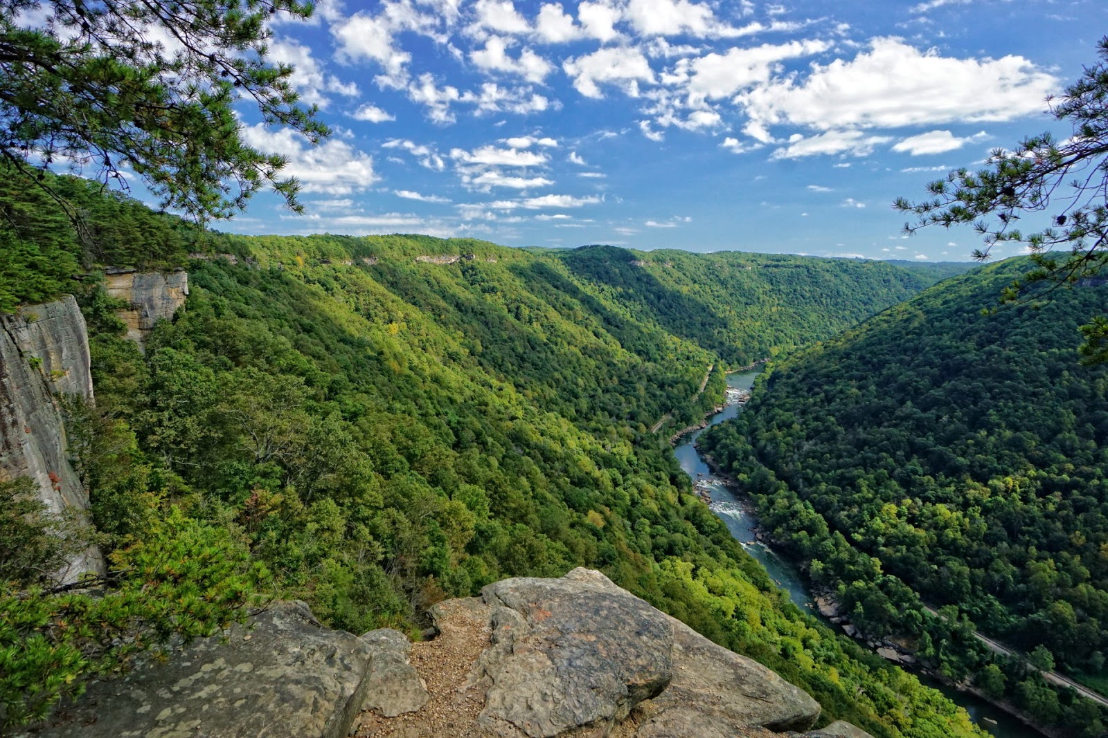
New River Gorge

New River Gorge

In November 1978, parts of the New River Gorge located in Fayette, Raleigh, and Summers Counties in southern West Virginia became the New River Gorge National River managed by the National Park Service. The New River was also designated an American Heritage River on July 30, 1998, one of fourteen such rivers in the country. The New River is reputed to be the second oldest river in the world. In 2015, USA Today readers voted the Endless Wall Trail of the New River Gorge National River as the #1 National Park day hike.
Sandstone Falls

Sandstone Falls

Located on the New River about 8 miles north of Hinton in Summers County, Sandstone Falls is one of the most visited landmarks within the New River Gorge National River. A 1/4 mile boardwalk provides fully accessible views of the falls. Not just a Wonder of West Virginia, Sandstone Falls is globally recognized. On a worldwide database of waterfalls, Sandstone Falls was ranked 30th by volume of water and 17th by width.

There you have it--a bucket list of places to visit in West Virginia. I know there are many other places worthy of the list such as Blackwater Falls, but I limited myself to seven wonders. But don’t limit yourself to these seven, for West Virginia is loaded with scenic wonders. 

Sunday, October 9, 2016

Fall Colors Popping on Camp 70 Road: Davis, WV

Just a short note to report that as of 10-6-2016 fall foliage colors were really starting to pop on Camp 70 Road out of Davis. It’s definitely a good road to drive to soak in some fall scenery. 
 At Bridge at end of Camp 70 Rd
Camp 70 road winds for five miles alongside the Blackwater River from the grocery store in Davis until it stops at the northern end of Canaan Valley. There are several trailheads for the Little Canaan Wildlife Management Area (LCWMA) along the road, and at the end of the road trails lead into the Canaan Valley National Wildlife Refuge. In addition numerous riverside campsites are strung along the road. Many provide access to the Blackwater River. 
Camp 70 Road
Two new bridges have been built across the Blackwater River for access to the Splash Dam South Trail which runs along the south bank of the river. The bridge near the end of Camp 70 road also connects with these trails in the CVNWR: #15 Canaan Mountain Trail, #16 Hellbender’s Tail Trail, #17 Shady Hollow Trail, and #18 Blackwater River Fishing Access Trail. 
Trailhead for #16
For hikers, mountain bikers, sight seers, and fishermen, Camp 70 road is worth knowing. It’s a vital access road to lands of the LCWMA and CVNRW and the Blackwater River. 
Camp 70 Road


Tuesday, September 27, 2016

Where to Go for Early Autumn Color in WV

Every year anticipation builds as fall approaches. Autumns can be glorious in West Virginia as leaves turn from green to gold. And every year we wonder what kind of a year will it be for color. Although much is known about why leaves change color, every year is different. So it’s difficult to predict how vivid the colors will be and what the timing will be. But here are some rules of thumb for where to best appreciate the first colors of autumn in West Virginia.
Highland Scenic Highway - 2012

Highland Scenic Highway

Leaves first start changing color at high elevation, so it’s best to start in the highlands. Although it varies yearly, fall foliage colors generally peak at high elevations in the last week of September to the first week in October. The Highland Scenic Highway (SR 150) is generally radiant with fall colors at that time of year. The Highway runs along the spine of the Allegheny Highlands in Pocahontas County, reaching more than 4,500 feet in elevation on Black Mountain. I like the Williams River Overlook for a panoramic view of fall color. About three miles north of the Big Spruce Overlook, you’ll find a host of brilliant red maples lighting up the hillside. 
Highland Scenic Highway - 2012

Summit Lake

Summit Lake (elevation 3,388), just 10 miles outside of Richwood on SR 39, is another early autumn venue for leaf color. Hillsides of brilliant color reflect in the lake, making an autumn paradise. Golden aspen trees line the trail to the fishermen’s dock. Summit Lake is a must for early fall color odysseys. It peaks about a week after the Highland Scenic Highway. 
Summit Lake - 2012

Blackwater-Canaan Area

Blackwater Falls State Park is another fall color hot spot. Particularly nice is the view of the Blackwater Canyon from either Lindy or Pendleton Points. Highway 32 south of Davis as it ascends to Canaan Heights often has spectacular fall colors. For that matter don’t forget Canaan Valley. The Beall Trails in the Canaan Valley National Wildlife Refuge are good for color. And I would definitely take the Scenic Chairlift Ride at Canaan Valley State Park. 
Blackwater Falls - 2008

Dolly Sods

At 4,000 feet in elevation the color change occurs early at Dolly Sods in Tucker County, too. Although the trees at Dolly Sods can be beautiful, the main attraction is near the ground. At Bear Rocks at the north end of forest road 75, the blueberry shrubs that carpet the earth turn a brilliant red. Acres and acres of scarlet earth--it’s a sight to behold!  
Canaan Valley - 2015

Snowshoe Mountain

There are couple of places in the highlands of West Virginia that I haven’t seen in the fall, but can recommend anyway. One is Snowshoe Mountain Resort in Pocahontas County. At elevations of 4,800 feet, fall arrives early and in glory at Snowshoe judging by some photos that I’ve seen.   
Dolly Sods - 2008

Spruce Knob & Lake

In western Pendleton County, Spruce Knob is the highest point in West Virginia (4,863 feet). Leaves will turn quickly at that elevation. A fisherman friend of mine likes Spruce Knob Lake for autumn colors. Standing at 3,840 feet in elevation, it is the highest lake in West Virginia. In the autumn the lake is encircled with slopes of reds, golds, and yellows. 
Dolly Sods - 2015

Well, I’ve tried to hit the high spots (pardon the pun) of early autumn color in West Virginia. If I’ve missed some places, please leave a comment. In another post, I’ll mention some places in West Virginia that hit peak color in mid to late October. 


Sunday, September 18, 2016

Hiking Sandstone Falls Never Fails to Amaze

What’s a waterfall lover to do when the weather is so dry? Head to Sandstone Falls in Summers County. That’s what Phyllis and I did last Friday. Although low, there was still plenty of splash and spray from the falls at Sandstone. In an earlier Post, I wrote about how to get the most out of a visit to Sandstone Falls. I took my own advice and went to the island of rock in the middle of the river that directly faces the falls. 
Sandstone Falls
The island is not a part of the boardwalk and trail system that the National Park Service (NPS) has made, but it’s easily hiked to with a little scrambling. Just take the path to the right just before the final overlook. You can’t miss the turn off. There’s a gap in the boardwalk and a sign reminding fishermen to wear floatation gear when in or near the water. Most people don’t take this scramble, which is a shame because it offers the most spectacular view of Sandstone Falls. 
Sandstone Falls
What is it like to be on the island, and what do the views look like? I’m posting some photos taken from Friday to illustrate. First, you see the falls up close and personal. They are literally right in front of you. This wall of water rushes at you, then turns away at the last second and is channeled to the left by the rock island. In my opinion it’s one of the grandest sights in West Virginia.
Sandstone Falls
Not only are the falls fun to explore and photograph, the flats to the right of the falls are interesting, too. Here the river is very shallow and the river bed is composed of rock scalloped into pools both large and small. It’s a great place to wander around in tennis shoes and cut-offs. 
 
Flats at Sandstone Falls

As a photographer, compositions seem endless. I spent some time working on a reflection from a pool carved in the bedrock near the falls, took some isolation shots of the main falls, and explored the flats for more reflections. The way the water flows over and through the falls, will intrigue you and keep a photographer occupied for hours. 
Sandstone Falls
This is a hike I can always recommend. Anyone who loves water, will love to explore Sandstone Falls. It never fails to amaze. For more information about how to get to the falls and what to do there see this NPS webpage Sandstone Falls.

Saturday, September 17, 2016

What are the Best Conditions for Brilliant Fall Colors?

Also important in the quality of a leaf color season is another chemical in leaves called auxin. Auxin controls a special band of cells at the base of each leaf stem, called the abscission (cutting away) layer. During the growing season, auxin prevents this layer from fully developing and blocking the tiny, internal tubes that connect each leaf to the rest of the tree's circulatory system. 
Babcock State Park
In fall, however, cooler and shorter days trigger an end to auxin production, allowing the abscission layer to grow and cut off the circulation of water, nutrients and sugar to the leaves. When this happens, chlorophyll disintegrates rapidly, letting carotenoids shine through as yellow and the anthocyanins as red. The color season ends when the abscission layer finally cuts the stem completely, and the leaf falls off. 
Babcock State Park
Tree Types and Color
Certain colors are characteristic of particular species. Oaks turn red, brown, or russet. In fact, in the absence of yellow or red pigments, oaks turn brownish due to another pigment–tannin. Hickories turn a deep golden bronze whereas aspen and yellow-poplar are golden yellow. Dogwood will turn purplish red and beech light tan. Sourwood and black tupelo are crimson. Maples differ according to species. Red maple turns brilliant scarlet; sugar maple, orange-red; and black maple, glowing yellow. Striped maple becomes almost colorless. Leaves of some species such as the elms simply shrivel up and fall off, exhibiting little color other than drab brown.
Babcock State Park
Best Conditions for Brilliant Fall Colors
Putting together all we’ve learned, what is the optimum scenario for a brilliant fall? The best weather for brilliant fall foliage is a growing season with ample moisture followed by a dry, cool and sunny autumn with warm days and cool but frostless nights. On the other hand, cloudy days, an early frost, strong winds, or heavy rains can all reduce the quality and length of the color season. In time, regardless of conditions, the brilliant leaves of autumn fade and fall to the ground. 
Dolly Sods: Northland Loop Trail
Which brings us to one last tidbit–why the season is called “fall.” The word fall comes from an Old English word feallan which means "to fall or to die.” The "fall of the leaf" was used to refer to the third season of the year when trees lost their leaves, but over time, the phrase was shortened to fall. Regardless of what we call the season, it’s a glorious time of year. Let’s hope the conditions are right this year for a brilliant fall!
Dolly Sods

Thursday, September 15, 2016

Why Do Some Autumn Leaves Turn Red?

Why some leaves turn red or orange is not simple to explain. The red pigments in leaves are made by anthocyanins, which give color to such familiar fruits as cranberries, red apples, concord grapes, blueberries, cherries, strawberries, and plums. Red maples, sugar maples, white ash, pin oak, sassafras, and other trees owe their brilliant hues of red to anthocyanin. 


Highland Scenic Highway
For years red pigments were thought to be leftover pigments, too, just as the yellow pigments. But current research has shown otherwise. As observed by seasoned fall color watchers, no two autumns are identical. Each fall, leaves differ in color and intensity. For instance, why does a maple go yellow one year and red the next? Red is the wild card color. It is not left over after the green is gone. Federal and state forest service researchers have discovered that the red pigments are produced under certain conditions by leaves during the approach and beginning of autumn. But, the how and the why of red pigment production are not fully known. 
Highland Scenic Highway
Temperature and light leading up to and during the fall season seem to be important. This leads to the third overall factor involved in leaf color change–the weather. Two weather conditions that apparently stimulate the production of anthocyanins, the red pigment, are sunshine and cool nights. Sunny days in September and October trigger the making of anthocyanins, and improve the chances for brilliant red leaves. Conversely, a majority of overcast days stifle red pigment production and lead to more yellows and browns. Orange leaves, by the way, occur when both yellow and red pigments are present. 
Summit Lake
Cool but not freezing temperatures at night also promote red pigment production. The thinking is that chilly nights prevent the leaves from sending all the sugars they made during the day into the twig and therefore they get trapped in the leaves. These trapped sugars are the backbone of anthocyanin synthesis and thus boost the red pigment production. At some time, which varies year to year, the first frost and first freeze will occur. Freezing conditions destroy the leaf's ability to manufacture the red pigments. So an early frost means an early end to colorful foliage.
Summit Lake
"Best Conditions for Brilliant Fall Colors" in a post to follow.
Dolly Sods

Wednesday, September 14, 2016

Why Do Autumn Leaves Change Color: Part 1

Why do autumn leaves change color? What controls the change, and why are the colors so different from year to year? Though I am far from an expert, the following is what I have been able to learn about the subject. 
Highland Scenic Highway
Three Prime Factors
The reason autumn leaves change color is far from simple. Some factors are well known, but scientists admittedly do not have all the details. The three prime factors controlling the color change are: 1) Leaf pigments, 2) Amount of light, and 3) Weather conditions. The color palette of leaves consists of three main pigments: chlorophyll, carotenoids, and anthocyanin. 
Babcock State Park
Chlorophyll is the green pigment, so to speak, and is essential for plant growth. Chlorophyll is an exceptional substance that converts sunlight into food for plants in a process called photosynthesis. Using energy from sunlight, chlorophyll combines water and carbon dioxide to produce oxygen and sugars. The oxygen mingles with the air we breathe and helps to sustain human life, which depends upon oxygen. The sugars are sent from the leaf into the tree to help it live, grow, and reproduce.

Leaves remain green as long as chlorophyll is plentiful. But chlorophyll is not a stable compound; bright sunlight causes it to decompose. To maintain chlorophyll in their leaves, plants continuously produce it, which requires sunlight and warm temperatures. Therefore, during the summer, chlorophyll in leaves is continuously broken down and regenerated. The trees of summer owe their lush green leaves to the abundance of chlorophyll in their leaves, which is constantly being destroyed and renewed by the summer sun.
Swinging Bridge at Babcock State Park
Yellow, the Left-Over Color
This leads to the second major factor determining the color change–light. As fall approaches, the days shorten, the amount of sunlight wanes, and the air cools. Like an internal clock, shorter days signal leaves to begin to shut down their food production. The shorter days mean more chlorophyll dies than is replaced. As chlorophyll begins to die off, other leaf pigments, which are masked by the green of the chlorophyll, are revealed. 
Aspen at Summit Lake
Present in the leaves all summer long, shades of yellow from the carotenoids finally begin to show through. Carotenoids produce yellow, orange, and brown colors in such plants as corn, carrots, daffodils, rutabagas, buttercups, and bananas. Striped maple, birch, aspen, hickory, poplar, ash, and other trees glow in shades of deep gold to pale yellow because of the carotenoids in their leaves. Ironically, the beautiful yellows and golds of autumn leaves are colors left over after all the chlorophyll has died out.
Summit Lake near Richwood, WV
In a post to follow I’ll discuss why leaves turn red.
For more on this topic click Why Leaves Change Color

Tuesday, September 13, 2016

Exploring the Endless Wall Trail to Diamond Point and Beyond

The Endless Wall Trail was voted the #1 National Park Trail by readers of USA Today (Endless Wall Trail). And for good reasons. Many stunning vistas of the New River Gorge line the trail. In this post I will highlight the best overlooks and other points of interest in a 2.6 mile loop trail of the Endless Wall.
Endless Wall from Diamond Point
Start at the Fern Creek Parking Area (GPS: Lat. 38.06298, Long. -81.05682) on the Lansing-Edmond Road (County Road 82) just 1.3 miles from its intersection with U.S. 19. The Endless Wall Trail begins by meandering on a flat, well graveled path through a lovely hemlock forest. After a half-mile, it crosses Fern Creek and begins a gradual ascent through a rhododendron thicket. As the trail tops the hill, the Fern Buttress Overlook takes off to the right at the 2/3 mile mark. The vistas are somewhat obscured by trees, but the viewpoint still gives you a sense of the depth of the gorge. On the right (north) side of Fern Buttress, paths zigzag to the top of a steel ladder bolted to a rock, which climbers use to reach the bottom of the Endless Wall cliff.
 
Fern Buttress Climbing Ladder

From the Fern Buttress continue hiking the cliff top trail and look for various paths to the right leading to the cliff edge. These paths lead to small bare rock outcrops with a view to the gorge. My favorite spot on this section of the trail is a spot I call the Idol Point Overlook (GPS: Lat. 38.05408, Long. -81.06075), which sits about 1000 feet east of Fern Buttress. Named by rock climbers, Idol Point is a stunning overhanging rock point at the top of the cliff. It sits mid-way between the Fern Buttress and Diamond Point. 
Idol Point: Endless Wall
Probably the best viewpoints on the Endless Wall trail are at Diamond Point, which is about 0.9 miles from the trailhead. Diamond Point juts out into the gorge and offers sweeping vistas upstream and downstream. It’s a “must-see” view of the New River Gorge. If you’ve packed a sandwich, it’s a great lunch stop, too. 
Diamond Point Overlook
Upon leaving Diamond Point, the trail gradually slopes downhill for about 30 yards. At the base of the downhill stretch look for a sign indicating climbers’ access. This side path leads to another steel ladder that descends into a narrow cleft in the rock. Called the “Honeymooner’s Ladder,” it’s another point at which climbers can access the bottom of the cliffs. If it looks scary, it is! Phyllis and I climbed this ladder once, and once was enough for us! Even if you’re not a climber, though, these Endless Wall ladders are worth a look. 
Honeymooner's Ladder
After the Honeymooner’s Ladder, the trail continues on the cliff top and rises gradually. There are still side trails to the edge of the gorge, but they are not as numerous as prior to Diamond Point. There is, however, one roomy outcrop at the 1.4 mile mark, which was called Falcon Point (GPS: Lat. 38.05634, Long, -81.05242). The Falcon Point trail is no longer marked by a sign, but it’s easily identified by two small pine trees growing together in the middle of the trail. It’s worth a short side trip and has great views upstream and downstream. 
View from Falcon Point
The cliff-side portion of the Endless Wall Trail ends at the 1.75 mile mark at the Miner’s Ladder. Before turning left to follow the trail over a ridge, continue straight ahead for a short stretch to a viewpoint overlooking the gorge. The view downstream is obscured by a rock outcrop with a small pine tree growing on top of it, but the view upstream is grand. While here, check out the climbers’ access ladder in the middle of a rock cleft. 
View from Miner's Ladder
The easiest way back to the starting point is to finish the remainder of the Endless Wall Trail, which wanders downhill through trees and rhododendron for a third of a mile to trailhead parking for the east end of the Endless Wall Trail. From the parking area turn left onto the Lansing Edmond Road; walk a half mile back to the Fern Creek Parking Area, and you’ll be back at the start. You’ll have hiked a loop of 2.6 miles and enjoyed some of the best scenery the New River Gorge has to offer.
Miner's Ladder


Saturday, September 10, 2016

Why I Don’t Worry About Goldenrod Allergies

Last Wednesday (Sept. 7, 2016) in Canaan Valley, Phyllis and I were awed by acres of Goldenrod gracing the slopes of the South Glade Run Crossing trail. We ambled through waist-high fields that glowed in both sun and shadow. And you know what? We didn’t sneeze, sniffle, or scratch our itchy eyes—not one time. We reveled in fields of gold without a hitch. That’s because Goldenrod is not to blame for allergy flare-ups. Ragweed is the real culprit. It’s estimated that 90% of pollen-induced allergies is due to ragweed. 
South Glade Run Crossing Trail
So why does Goldenrod get the blame? Probably because Ragweed and Goldenrod bloom at the same time of year—late summer and early fall. Since Goldenrod is by far the showier of the two plants, people notice Goldenrod and fault it for the allergies. Ragweed, on the other hand, is a small plant with a short stem of green or white blossoms. It’s not nearly as conspicuous. People see the bushy stems of Goldenrod covered with flowers and think pollen! 
 
South Glade Run Crossing Trail

Indeed, when inhaled, pollen from plants can cause allergic reactions. But the pollen from Goldenrod differs greatly from that of Ragweed. Plants employ pollen to reproduce, but rely on different modes of transport from plant to plant for pollination. Ragweed relies on air-borne pollen to reproduce. To be picked up by the air and wafted to another plant perhaps miles away, Ragweed pollen must be small and light-weight. There’s a numbers game, too. To increase the odds of pollination, a single Ragweed plant can produce up to a billion grains of pollen in one season. With the air so full of Ragweed pollen, those susceptible to allergies are bound to suffer.
Monarch Butterfly on Goldenrod
In contrast, the pollen of Goldenrod is much larger than Ragweed. It’s too large to be picked up and carried by the wind for any distance. Instead, Goldenrod relies on butterflies and bees to carry pollen from one plant to another. Being a more direct way of transportation, less pollen is needed. 
South Glade Run Crossing Trail
That’s why I don’t worry about Goldenrod allergies. Instead I enjoy fields of Goldenrod without fear. And so can you. As I mentioned at the start, there’s plenty of Goldenrod on the South Glade Run Crossing trail in Canaan Valley. See my post of September 2nd for more about this trail and how to enjoy it. South Glade Run Crossing Trail Post

For a Canaan Valley National Wildlife Refuge Trail map click this link: CVNWR Trail Map.